
On these pages you can find something of the history of Ludwell Valley, going back thousands of years and then right up to the present.
If you find anything wrong, please let us know; if you have any stories to add, we would love to hear from you. You can get in touch via our Facebook group or by e-mail to [email protected].
These pages were last updated on 18th November 2019. The main changes are a lot more information on Pynes Hill Farm, a more accurate and complete list of the old field names and the people who farmed them in the past, and an updated history of the valley in the 20th and 21st Centuries, including the story of Edgar & Hilda Snow, who owned Ridgeway and Ludwell Gardens.
You can return to the top of the page by clicking the up arrow that appears at the bottom right of the screen when you scroll. Click on the images to view larger versions.
There are many reasons why. We all have our own list, but here are a couple of reasons from history.
Ludwell valley is a place people have been drawn to since the neolithic period. It has been continually used and occupied for 6,000 or 7,000 years. There is nowhere else in Devon that can say this. (See the section ‘Ludwell clay is special’)
A lot of early pottery found on sites elsewhere in Devon has been shown to have been made from clay from Ludwell Valley. No evidence of pottery kilns has been found, so people must have thought Ludwell Valley clay good enough to be worth the journey to collect it. And then to take it away for potting and firing. (See the section ‘RAMM: Making History Collection’.)
According to the Dictionary of English Place Names, the derivation of “Ludwell” is from two Old English words: “hlude”, meaning loud, with “hlaw”, a hill; and hence “the loud (or rapid) river by the hill”. So where was this loud river?
There is a spring, now under the kitchen floor of Ludwell House. It may be that this spring flowed into an old watercourse, which Ludwell Lane now follows, flowing down to join the Northbrook. Devon’s most famous historian, W. G. Hoskins, suggested the name means “loud spring”, which would be consistent with this theory.
However, another dictionary, the Online Etymological Dictionary, suggests “hlaw” translates not only as hill but also mound, especially a barrow… So was there a prehistoric burial mound, one thought to be the haunt of restless unquiet spirits of the ancestors?
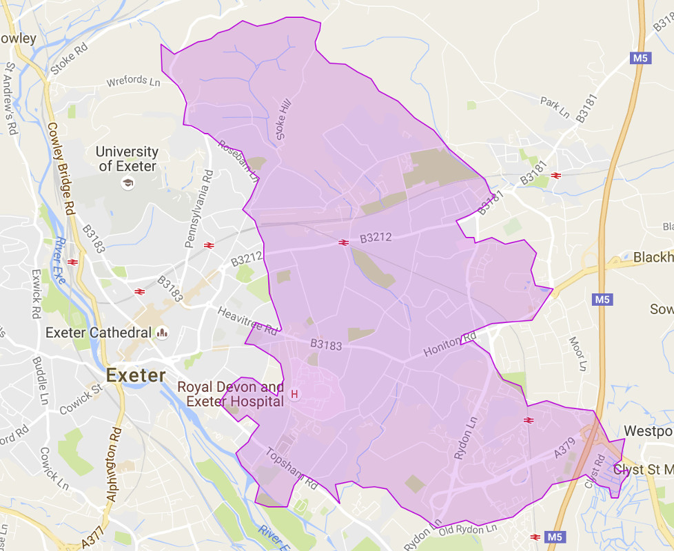
Nearly all of Ludwell Valley Park is the ancient parish of Heavitree – only the part of the playing fields nearest the Topsham Road and the last stretch of Northbrook before it runs under the Topsham Road are in Topsham parish. But Wonford is an even older name, and it comes from a rather surprising source…
The old name for the Northbrook, recorded in a Saxon charter of 937 AD, was Wynford. This probably derives from the Celtic “gwyn ffrwd”, meaning the white, fair or holy stream. So our local rather polluted and sometimes neglected Panny was known by local people long ago as a particularly attractive or even holy stream.
“Wynford” in turn changed over time to “Wonford” and so the stream gave its name to the manor of Wonford, which belonged to the Saxon kings. This was the name that became accepted for the ancient Hundred. However, the village of Heavitree, built on the main Exeter to London road, gradually became more important than Wonford. Wonford had ceased to be a royal manor in the twelfth century, and so Heavitree is the name the parish has been known by ever since.
(A Hundred was an Anglo-Saxon administrative area, pre-dating counties, districts or parishes. It remained the intermediate area between parish and county right up until 1894. It was originally called a Hundred because it was made up of one hundred hides: a hide being the amount of land a family needed to support themselves – so a hide would be a much smaller piece of land in a fertile area like Ludwell valley that in it would somewhere like Dartmoor.)
If you walk up the footpath running up from Ludwell Lane by the side of the Fernleigh Nurseries, pause at the top and look out over Wonford Playing Fields. You can see how the path rejoins Ludwell Lane and aligns precisely on Heavitree Church. Perhaps Ludwell Lane originally ran straight to the church, and the modern alignment is to avoid the steep slopes?
The other end of Ludwell Lane now disappears under Rydon Lane, the inner by-pass, and the Rydon Lane Retail Park, at which point it used to join the old A38. And this is the area where one of the two main local Iron Age encampments was! Could Ludwell Lane have followed an route used by our Iron Age ancestors over 2,000 years ago to travel between one of their main settlements and the sacred site marked by an ancient yew tree which you can still see today and which may have given its name to…Heavitree?
The old hedge lines are thought to have been created by the first farmers cutting back into the woodland to make a clearance, with other farmers cutting back in from the other side, so that the hedge is the furthest extent of that clearance and represents the remnant of the primeval woodland. Indicators of the age of a hedge are the number and type of species in it; wood anemone and bluebells; and dormice, which don’t readily expand their range. Fields were typically 4 to 5 acres (as are most of the Ludwell fields). More modern hedges tend to be straight and are often predominantly elm.
The hedge running along the southern edge of the Vets Field (parallel to and south of Ludwell Lane and Fernleigh Nurseries) is probably the oldest in the valley, with a meandering line, a range of species including old spindle and old coppiced ash.
St Loyes Chapel lies a little to the north east of the Valley Park, just off Hurst Avenue. It was built in the thirteenth century. No-one knows why it was dedicated to St Loye. He was a seventh century French goldsmith who became bishop of Noyau and was adopted as the patron saint of all metalworkers. It was no longer in use as a chapel by 1607, when part of it was let as a dwelling house and by 1785 it was a stable!
In the 1890s, the vicar, Rev. Berkeley, tried to raise funds to restore it, but the scheme foundered and so now only the ruins remain. You can go and see the remains of the chapel which is on Rifford Road, just down from the Lethbridge Road crossroads. There were also almshouses dedicated to St Loyes, on Salters Road, but they are no longer there. Modern houses now stand on that site.
The City Council started buying land in the valley from the late 1920s onwards as part of a larger area for housing, first to rehouse people from the old West Quarter and then after the war, to replace houses destroyed by enemy bombing. Most of the land is now the Rifford Road and the Burnthouse Lane estates. Ludwell valley was spared, presumably because the land was too steep, and Wonford Playing Fields because the land had been used as a tip, and then for dumping some of the rubble from the wartime bomb damage.
Although the Council continued – and continues – to buy up land as opportunities arise, some fields remained in private ownership. A particular interesting example was the Snow family. Edgar and Hilda Snow were landlords of the old Country House Inn on Topsham Road. They did well there and in 1920, bought Ridgeway field, and then Ludwell Gardens in 1928. This was productive arable land, and also good for bulb growing. They developed a commercial business – sending daffodils and other flowers for Covent Garden market in London, with, it is said, flowers even being exported to Holland! Tulips to Amsterdam! The family only sold these fields to the Council in 2019.
Just in front of Ridgeway, opposite the new cherry orchard, is Ludwell House and several new houses, situated where there was a garage until as recently as 2005.
Just along from Ridgeway are Fernleigh Nurseries. The present owner rents them out. The previous owner kept chickens and guinea fowl and as protector of his birds, shot foxes! The buildings you see now are relatively modern – but Francis Hurford, the owner of Pynes Hill Farm from 1923 to 1944 (see the section on Pyne’s Hill Farm) lived at Fernleigh back nearly a 100 years ago, so perhaps there was once an older house there.
On the other side of Ludwell Lane is the old Cherry Orchard. The oldest trees over 100 years old – maybe as old as 115 years, which is a very good age for fruit trees. There was also an apple orchard until quite recently on Long Meadow further along on the east bank of the Northbrook – where Woodwater Lane playground is now.
A little further down Ludwell Lane is Allery’s House. Its tenants farmed Great Ridgeway and possibly two other fields – Little Three Acres and Bean Wood. They followed the valley tradition of keeping pigs. They left in about 1996, after which the Council sold the house. It is now in private ownership.
Once the Council took over ownership of fields in the park, they installed tenant farmers. The last tenant was Bernard “Tiger” Hooper. He was said to be a strong willed man. He grazed his cattle on the park all year round, which made it a muddy and smelly experience for walkers, although some field edges were fenced off for them. He had a piggery where the new cherry orchard has been planted; full of old railway carriages, gates and vicious dogs! When Tiger died in 1998, the Council decided to take back the management of the land in order to have better control.
In 1983, the City Council took the far-sighted decision to create three valley parks in Exeter, one of which was Ludwell Valley. There is no use of herbicides, pesticides or artificial fertilisers, so the park is a haven for wildlife. The valley is still used to graze cattle in the summer months, but is open to us all to enjoy nature and the views over the city one way and right down the estuary to Exmouth the other. It is there for us, to walk, to exercise our dogs or just to play. And 2019 is the start of the next chapter in Ludwell Valley’s history as Devon Wildlife Trust takes over its management.
Ludwell valley is a place people have been drawn to since the neolithic period and shows a 6,000 – 7,000 year continuity of use and occupation not found elsewhere in Devon. People used the flint and other stones to make tools such as blades and scrapers; then later, from the Iron Age onwards, they used the clay for pottery; the land for agriculture.
A number of finds, some of which are described below, have been found in the valley. These are stored in RAMM’s off-site store in Marsh Barton, viewable by appointment. Good examples from other sites in the area are on display in the Museum in the “Making History” gallery.
1. Neolithic and Bronze Age finds:
(All members of the community would have known how to make these tools, which could be easily carried with you and easily replaced when they broke or became too blunt)
2. Seventeenth Century pottery fragments
3. Bronze Age cremation urns
(Record from Devon Heritage Centre)
This was in a field just the other side of the Topsham Road, opposite what is now Wonford Playing Fields and the Burnthouse Lane estate. There was a beaten footpath running through Northbrook grounds, then a little way south-west along a track leading from Topsham Road to the back way into Northbrook Lodge, and thence along the north-western edge of a field belonging to Captain John Lowe towards the old abbey (which was opposite Salmonpool Weir, further in towards the city centre)
Captain Lowe, who lived at Fairfield Lodge, next to the field, applied to the magistrates to replace the path with a wider one, gravel surfaced, nearer the hedge and with a very slight bend straightened out. His argument was that “by taking away the present curved form it is evident that the path will be considerably shortened and made in every respect of more comfort and utility to the passengers’. All this he offered to do at his own expense. But less you think what a public spirited man, there was also an ulterior motive. He also admitted that “the intention is to fence the field from trespass with as little loss of ground as possible”. That is, by moving the path nearer to the hedge he could fence the path in and reclaim more of the field. The magistrates granted his request.
The field was 565 feet long and about 200 feet wide; bounded to the south-east by the track from Topsham Road, to the south-west by Mr Rooke’s meadows and to the north-west by Captain Potbury’s field and garden.

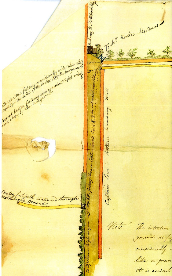
There is an interesting parallel here. This same footpath still exists but has been re-routed two more times, both much bigger diversions. It still runs from School Lane across Northbrook golf course but then used to go straight through what is now Millbrook and Millfield, then across what is now Isca Academy and straight to the site of the old abbey. With the building first of the school and more recently of Millbrook Village and the Glade, the footpath has again been diverted, now running much nearer the backwater of the river Exe.
(Record from Devon Heritage Centre)
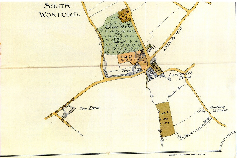
George Havill owned a fine house, orchard, farm buildings and five cottages in Heavitree, plus a small field in what is now Wonford Playing Fields. After his death, it was all sold at auction. The auction was held on 25th May 1909 at the Half Moon Hotel in Heavitree; the auctioneer was Herbert Fulford of 5 Bedford Circus in Exeter, who was selling it on behalf of the Union of London and Smiths Bank. Was the bank his executor, or were there debts to be paid off?
Mr Havill had only owned the field for 17 years, having bought it from a Frederick William Arundell Sanders in 1892. The field was small, about one and two thirds acres (1 acre and 12 perches), with a right of way from Ludwell Lane. You can see it on this map, which also shows the Carpenters Arms, which only closed in 1998, and, on Ludwell Lane, Sydney Cottage.
The farm was on the opposite side of Ludwell Lane to the Fernleigh Nurseries in the corner of what is now the Cherry Orchard. It had been there since at least the 19th Century, and probably a lot longer, but was gone by the 1960s, and possibly by the 1940s. But there are still signs if you look carefully enough. The gateposts of the entrance to the Cherry Orchard from Ludwell Lane are solid stone affairs, very different to the more modern gateposts used elsewhere in the park by the Council. They are in fact the gateposts of the old farm entrance. And near the cattle’s drinking trough you can find the odd brick or fragment of floor, all that is left of that farm.
1871:
Samuel Melhuish was living in Pynes Hill Farm at the time of the 1871 census and had probably lived there for many years before. He rented the farmhouse and 16 fields in the valley from the Rev William Arundell, the rector of Cheriton Fitzpaine. Samuel died later that year at the fine old age of 89 and the Rev Arundell two years later, in 1873.
1913:
After this, it is hard to trace who owned the farm or who lived there for several years. A man called Joseph Risdon owned it in at some point, but by 1913, Richard Blatchford was the owner.
1923:
Richard Blatchford sold the farm to Francis John Hurford for £4,000. Richard Blatchford owed £1,500 on a mortgage he had taken out on the farm in 1913, which he was required to clear from the proceeds of the sale. It suggests he was forced to sell by his creditors.
The farm consisted of 59 acres, 2 roods and 39 perches. As well as the farm buildings, there were 13 fields, of which 8 were pasture, 4 arable, one meadow (Wood Meadow) and part of one field (Southern Ridgeway) was given over to timber. The other fields were
The farm was sold subject to Joseph Risdon, the previous owner, who was obviously still farming in the area, having a right to drainage from his manure pit in Beam Wood and his slaughter house in the field now built on and called Aspen Close. (There was still a slaughter house at Woodpark, Woodwater Lane in 1956, probably the same one.)
Francis Hurford took out a series of mortgages for £2,500 on the farm between 1926 and 1936. He also leased out much of the farm at least once.
1932:
Francis Hurford, now of Fernleigh, just the other side of the lane, leased a large part of Pynes Hill Farm to Mark White of Hallhayes Farm in Wellington, Somerset. This included the fields known as Northern Ridgeway, Pine Close, Six Acres, Three Acres, Four Acres, Long Longcombe, Oak Close, part of Southern Ridgeway, Wood Meadow and the house and farm buildings. All the fields apart from Wood Meadow were laid to pasture. The rent was to be £190 a year.
The lease included a number of strict conditions. Mr White was not to break up any permanent pasture; if he did there would be a fine of £100 per acre. He was to preserve all the trees in the Cherry Orchard, replacing them as necessary. (Some of these trees still stand today.) He was to keep at least 40 apple trees and currant bushes in the garden. He had to manage the farm “according to the best rules of husbandry practiced in the neighbourhood”. He was to prevent, as far as possible, any trespass onto the land. Finally, he had to purchase the farm’s milk round after one year.
All the hedges were to be maintained in good condition, apart from two which were “not to be kept up”. These were the one running along the top of Longcombe and the adjoining field against Ludwell Lane, and the hedge between Northern Ridgeway and Wood Meadow. So was it agreed that these hedges could be ripped out? They are both still there today.
1938:
In this year, Francis Hurford decided to sell – or had to resort to selling – two fields, Northern Ridgeway and Wood Meadow to Exeter City Council, totalling 7.8 acres, for £1,000.

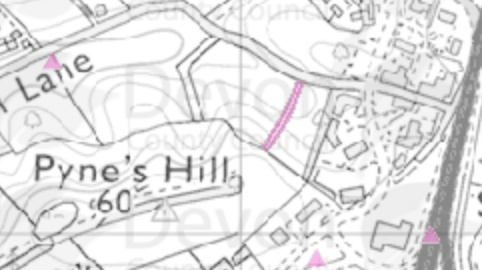
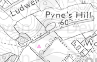
In 1947, the City Council granted the tenancy of these fields, now just called Hillyridge, to Clifford Northcott, butcher, of 58 South Street, Exeter. The rent was set at £30 a year and the field was to be used only for grazing. You can see the land, coloured pink, on this map, with the footpath from Ludwell Lane towards Heavitree church crossing it.
1942:
Pynes Hill farmhouse and other buildings suffered bomb damage on 4th May 1942, the night of the major Luftwaffe air raid on Exeter.
1944:
Francis Hurford, who was still living at Fernleigh, sold almost all the remaining farm (43 acres) to Exeter City Council for £5,250. Amongst the few bits excluded was a shed let to W. Simmons, which he was to be allowed to continue to occupy for his lifetime. The war damage compensation due to Mr Hurford was to pass to the Council as a result of the sale.
(43 acres, plus the 8 acres sold in 1938 makes 51, yet the farm had been recorded in 1923 as having 59 acres. What happened to the other 8 acres? Did Francis Hurford have to sell off a couple more fields at some point?)

On 25th August 1947, the City Council granted the tenancy of Hillyridge field to Clifford Northcott of 58 South Street. Mr Northcott was a butcher. The rent was set at £30 a year; this for a field of “about 7.667 acres or thereabouts”. The field was to be used only for grazing – cattle presumably. You can see the land, coloured pink, on this map, with the footpath from Ludwell Lane towards Heavitree church crossing it.
In the early 1840s a map, called a Tithe Map, was drawn up for each parish. The purpose was to assess who owed tax and how much. Most of the tax was due to the vicar or parson, replacing the old system whereby farmers and smallholders had to give one tenth (a tithe) of their produce to the vicar every year. The maps record the name of every field, its size, whether it was arable or pasture, who owned it and who farmed it.
Ludwell Valley fell within Heavitree parish. Heavitree’s map was drawn up in 1843. The vicar, it was calculated, was owed £450 a year; other lessees another £580. To put it in perspective, it would take a craftsman about 8 years to earn £450 in the 1840s!
You can see the old field names marked on this map. The tables below set out who owned each field, who farmed it and how it was used.
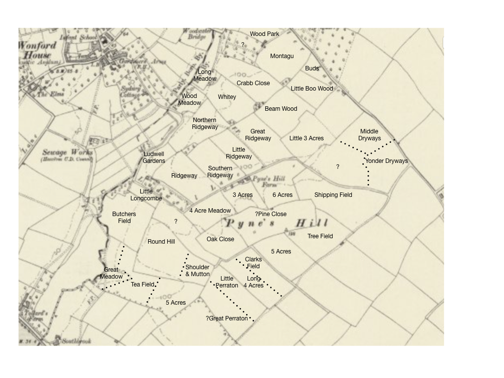
This first table lists the fields between Ludwell Lane and Burnthouse Lane starting from the Woodwater Lane end. The first seven have since been built on.You will see as well there are a few fields we haven’t been able to read the names of on the old map which is in very poor condition.
| Name of Field | Type | Owner | Occupier | |
| 1 | Wood Park | Arable | Francis William Spicer | himself |
| 2 | Montague | Arable | Francis William Spicer | himself |
| 3 | Buds | Arable | Rev. William Harris Arundell |
Samuel Melhuish |
| 4 | Little Boo Wood | Arable | Francis William Spicer | himself |
| 5 | Dolly 7 Acres | Arable | Francis William Spicer | himself |
| 6 | Middle Dryways | Arable | Francis William Spicer | himself |
| 7 | Yonder Dryways | Arable | Francis William Spicer | himself |
| 8 | Long Meadow | Arable | Rev. Jonas Dennis | James Capron |
| 9 | ? | Orchard | ? | ? |
| 10 | Crabb Close | Arable | Pitman Jones | himself |
| 11 | Beam Wood | Arable | Francis William Spicer | William Rewe |
| 12 | Little 3 Acres | Arable | Francis William Spicer | William Rewe |
| 13 | ? | ? | ? | ? |
| 14 | Whitey | Arable | Rev. Jonas Dennis | James Capron |
| 15 | Great Ridgeway | Arable | Rev. Jonas Dennis | James Capron |
| 16 | Wood Meadow | Meadow | Rev. William Harris Arundell | Samuel Melhuish |
| 17 | Northern Ridgeway | Arable | Henry Manning, Esquire | Thomas Swale James Petheridge |
| 18 | Little Ridgeway | Arable | Rev. Jonas Dennis | James Capron |
| 19 | Southern Ridgeway | Arable | Henry Manning | Thomas Swale James Petheridge |
| 20 | Ridgeway | Arable | Rev. William Harris Arundell | Samuel Melhuish |
| 21 | Ludwell Meadow/ Gardens | Arable | Henry Manning | Thomas Swale James Petheridge |
This next table lists the fields on the other side of Ludwell Lane, running alongside the lane, then working across towards what is now the Pynes Hill Business Park.
| Name of Field | Type | Owner | Occupier | |
| 1 | Shipping Field | Arable | Francis William Spicer | William Rewe |
| 2 | 6 Acres | Arable | Rev. William Harris Arundell | Samuel Melhuish |
| 3 | 3 Acres* | Arable | Rev. William Harris Arundell | Samuel Melhuish |
| 4 | 4 Acres | Arable | Rev. William Harris Arundell | Samuel Melhuish |
| 5 | ? | ? | ? | ? |
| 6 | Little Longcombe | Arable | Rev. William Harris Arundell | Samuel Melhuish |
| 7 | Butchers Field | Meadow/Arable | George Francis Travers | Richard Maxey Hellings |
| 8 | Great Meadow | Meadow | George Francis Travers | Richard Maxey Hellings |
| 9 | Round Hill | Arable | George Francis Travers | Richard Maxey Hellings |
| 10 | Tea Field | Arable | George Francis Travers | Richard Maxey Hellings |
| 11 | 5 Acres | Arable | George Francis Travers | Richard Maxey Hellings |
| 12 | Shoulder & Mutton | Arable | George Francis Travers | Richard Maxey Hellings |
| 13 | ? Oak Close | Arable | Rev. William Harris Arundell | Samuel Melhuish |
| 14 | ? Pine Close | Arable | Francis William Spicer | Robert Davey |
| 15 | Tree Field | Arable | Francis William Spicer | Robert Davey |
| 16 | 5 Acres | Arable | Francis William Spicer | Robert Davey |
| 17 | Clark’s Field | Arable | John Stagden | Sarah Vicary |
| 18 | Long 4 Acres | Arable | John Ellis Lee | Robert Davey |
| 19 | Little Perraton | Arable | Sir John Thomas Buller Duckworth | Robert Rookes |
| 20 | Great Perraton | Arable | Sir John Thomas Buller Duckworth | Robert Rookes |
*Now the old Cherry Orchard
Fields were fairly small, typically 4 or 5 acres. Unlike today, most fields were used for arable crops. Most landowners were men holding a fairly small number of fields, although a few owned larger holdings, up to 50 fields and over 200 acres. Landowners generally rented out most of their fields to one single tenant farmer.
Lord Poltimore was the biggest landowner in Heavitree parish, although his estate didn’t include any of Ludwell Valley. Henry Manning was another big landowner with 48 fields, although only three were within the valley. George Travers had 27 fields in the parish, including 6 within the valley, all farmed by Richard Hellings. The Rev. Arundell owned 23 fields in the parish, plus farmhouses, 9 of which were in the valley; Samuel Melhuish farmed all but six of them. The Rev. Dennis owned another 5, all farmed by James Capron. Pitman Jones, Esquire, had four others elsewhere in the parish as well as Crabb Close. Francis Spicer had another six fields elsewhere the parish as well as his 11 in the valley.
The other landowner of note was Sir John Thomas Buller Duckworth, Baronet, of Wear House. He owned just the two fields in the valley, but on the other side of the parish boundary, in Topsham, he owned houses, cottages and about 250 acres of land.
Just one field out of the 41 in the valley, Clarks Field, was farmed by a woman, Sarah Vicary.
The estate passed after Sir John’s death in 1887 to his son, Sir Dudley Gordon Alan Duckworth King. Sir Dudley died in 1909, leaving the estate in tun to his son, Sir George Henry James Duckworth King. Under the provisions of Sir Dudley’s will, the house and estate was to pass, under a legal provision called ‘fee tail’, down from eldest son to eldest son for the next 150 years.
However, George was able to start selling the estate as soon as he came of age in 1916. Of particulate interest to us, he sold 5 fields in 1921, one of which was Perraton, now in Ludwell Valley Park; the other four are now the Southbrook and Bishop Westall estates. By 1927 the whole estate had been put up for sale. So end the ambitions of the rich and famous!
Another aspect of the valley that has been identified by recent archaeological work is the fact that a lot of early pottery found on sites elsewhere in Devon has been shown to have been made from clay from Ludwell Valley. No pottery kilns have yet been found though,so people must have thought Ludwell Valley clay good enough to be worth the journey to collect it. And then to take it away for potting and firing.
Alluvial clays deposited in the bottom of the valley 280 million years ago were used to make pottery in the Iron Age and Roman times. Some Roman tiles were almost certainly made from this clay, as was pottery found on the two major Iron Age settlements, one of which was where the new Exeter law courts now are, the other the one on the Rydon Lane site now occupied by Tesco.